After the Revolutionary War,
the U.S. Government established laws to survey and sell land gained from
Britain. The area that became Alabama was originally part of the Mississippi
Territory from 1798 to 1817. Many settlers arrived in the area before government
lands had been surveyed. Unable to buy, they simply picked a location, built a
cabin, cleared fields, and put in crops. Such families were called squatters.
Land laws were passed to provide legal title to land for settlers who already
lived on the land. Some settlers claimed land by British or Spanish land grants, and
others were squatters who claimed land by right of pre-emption....Starting in
1804, U. S. Land Offices were established to sell land in the area which would
become Alabama. By law federal land was sold to the highest bidders at public
auctions. Alabama sales attracted men from all over the nation, many of them
speculators. Groups of speculators bought large tracts, sometimes for as little
as $10 an acre, then resold at $20 to $100 an acre. When an auction ended,
poorer migrants could buy less desirable land for as little as $2 an acre. The
smallest amount one person could buy was 160 acres. Under the Land Law of 1800 a
purchaser could put one-fourth down and pay the rest off over three years. But
when the price of cotton fell to eighteen cents a pound, few could meet payments
on land bought at inflated prices. By 1820, Alabama owed the federal government
$11 million--more than half of the national land debt. In 1820 and 1821 Congress
passed new laws to deal with this problem. The Land Law of 1820 required future
buyers to pay the entire amount in cash but lowered the minimums to $1.25 an
acre and 80 acres. Those already in debt were aided by the Relief Act of 1821
which permitted them to keep part of their land and return the rest to the
government or buy it all on the installment plan at reduced rates. Introduction
to the Settlement Unit: The defeat of the Creek Indians opened the heartland of
Alabama to white settlement and caused Alabama fever to sweep the nation.
Pioneers by the thousands left Tennessee, Georgia, the Carolinas, and Virginia
seeking fertile land for growing cotton. Mississippi territorial law was in
place, but when Mississippi became a state, Congress created the Alabama
Territory in 1817. Congress designated St. Stephens as capital of the Alabama
Territory and approved a legislature of Alabama delegates already elected to the
old Mississippi territorial legislature. William Wyatt Bibb, a Georgia physician
who had served in the United States Congress and had powerful friends in
Washington, was named Territorial governor. He was also elected as the first
governor when Alabama became a state December 14, 1819. See his burial ground on
Coosada Road as you leave Millbrook, approaching the Coosada Baptist Church on
the left. One of our Carter's Uncle Frank Fenn donated some of his land in Coosada for a cemetery and his family is buried behind the fence.
The Bibbs and the Bozemans
were close friends, and neighbors in the early days. Benejah Bibb signed many of their legal documents. William helped establish the
government, pass laws and administer justice. The following documents deal with
cost of government, land speculation, cotton, and law as settlers poured in the
area during the early settlement of Alabama.At the start of the 19th century,
Indians still held most of present-day Alabama. War broke out in 1813 between
American settlers and a Creek faction known as the Red Sticks, who were
determined to resist white encroachment. After General Andrew Jackson and his
Tennessee militia crushed the Red Sticks in 1814 at the Battle of Horseshoe Bend
in central Alabama, he forced the Creek to sign a treaty ceding some 40,000 sq
mi (103,600 sq km) of land to the US, thereby opening about three-fourths of the
present state to white settlement. From 1814 onward, pioneers, caught up by what
was called "Alabama fever," poured out of the Carolinas, Virginia, Georgia,
Tennessee, and Kentucky into what Andrew Jackson called "the best unsettled
country in America." Wealthy migrants came in covered wagons, bringing their
slaves, cattle, and hogs. But the
great majority of pioneers were ambitious farmers who
moved.
Many of our families
were the early pioneers when Alabama first became a state, after being part of
the Mississippi Territory which was then mostly Choctaw land. South Alabama was
Creek but slowly most tribes were moving westward. Georgia did not allow
plantation owners to employ indians but Alabama did. The land was cheap and
fertile so the migrations began. Most used Biblical names for their children yet
some named them after popular native americans. Several are recorded in various
county history books and the Pintlala Historical Assn has many in their webpage
whom we are very proud of. As we stand on the capitol steps and admire the star
where Jefferson Davis took his oath as President of the Confederacy, we can look
around and know that many of our relatives also stood nearby to witness this
wonderful moment. And across the street we can walk through his home, which had
actually been moved from Ramer, where he resided near our families. Our families
were honored to serve in the many battles of the early 1700s and 1776, settling
in land grants of North Carolina and South Carolina. Anderson, Bozeman,
Brack, Broadway, Carter, Calloway, Campbell, Dillard, Flinn, Fountaine,
Gibson, Hill, Joiner, Mason, Mills, McClain, McGee, Sellers,
Shackleford, Stephens, Watson, Williams, Boothe, Bush, mostly intermarried,
some to their first cousin, some to their second as quoted in the book of 1885,
Sketches of Bozeman, we began to notice it more as the research continued. The
wagons flowed into Alabama by 1820 and land purchases are found in the 1820s as
these families are found on the 1830 Alabama census, all living so close
together, from Hope Hull to Ramah, as more and more new settlers joined them in
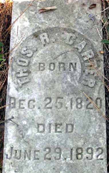
the years to come. John W. Carter bought land in 1821 but was on the 1820
census of Talladega yet his son Thomas was in Hope Hull marrying Peter Bozeman's
granddaughter in 1848. Peter's brother John bought land here in
1823. Peter's son Jesse M. bought land in 1827 and we found his grave in
Hope Hull off McLean Road by his daughter Lacy and her spouse Thomas Carter and
some of their infants. A map of these lands indicate the possibility that Peter
and his wife lived across the road "McLean" on his own farm and neighbors say
there is another cemetery we should explore on that side. We have to
remember that street did not exist in 1827.
In Darlington Peter had
his land surveyed in 1826 after giving some Deed Gifts to his grandchildren, and
in 1828 his letters to the War Department are found in Montgomery Alabama
archives. He was an invalid and requesting his pension to follow him here,
as witnessed by E.
Stephens.
Peter had served with
his brothers and their father and several other Bozemans, as they were so very
dedicated to our country.